
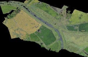
Surveys performed with RPAS
 You can open the binary files in .las standard format and directly store it.
Opening can be performed by the full point cloud or with the possibility to define an import offset compared to a predefined axis, so as to store only the affected range to speed up the subsequent operations.
Importing provides the automatic recognition of RGB colors, reflectance degree and possible classification.
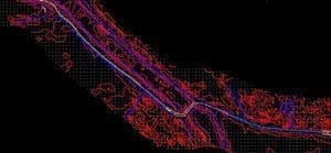
You have the possibility to carry out points classification (if not performed) by identifying by zones (also with the application of filters for quotes) the RGB colors belonging to standard categories of different points (soil, high / medium / low vegetation, buildings, water, etc.). Direct extraction of longitudinal profiles and cross sections related to defined planimetric axes, with amplitude setting of the area to be extracted, and the minimum distance between the extracted points and any altimetry filters.
 Generation of points cloud grid with possibility to define: the grid amplitude, the maximum height difference to automatically eliminate, where possible, points not belonging to the ground; automatic filling of not detected areas. On the model calculated using the appropriate algorithm can be inserted break lines graphically created using the orthophotos of the area, with automatic quotas calculation. With a powerful graphical editor on points or areas you can make all the changes necessary to get the correct model.
For this type of application you will need these Strato modules:
Plans (unlimited points).